 EMODnet Product Catalogue
Geological Survey Ireland
Type of resources
Available actions
Topics
Keywords
Contact for the resource
Provided by
Years
Formats
Representation types
Scale 1:
Resolution
-
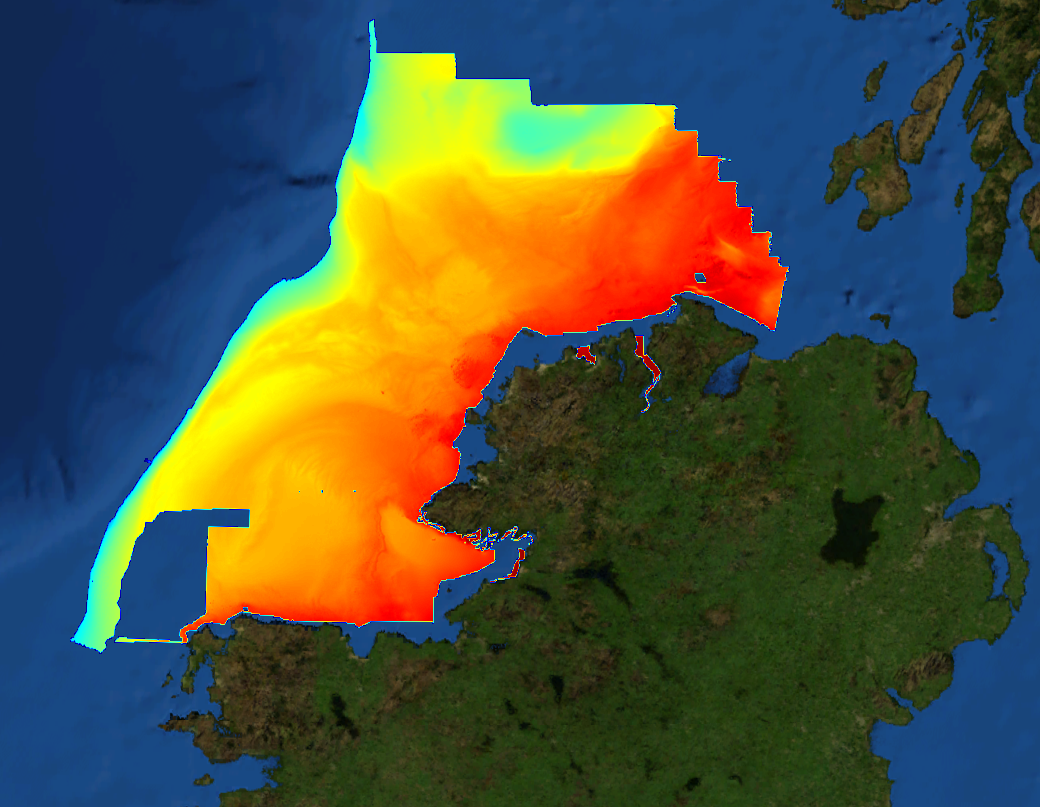
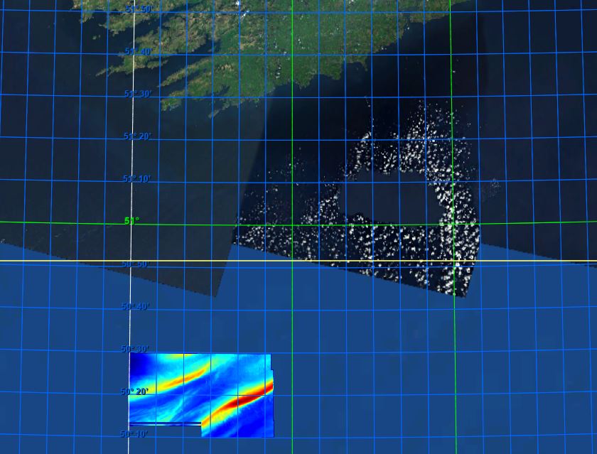
This composite Digital Terrain Model (cDTM) is a high resolution bathymetry dataset highlighting measurement of depth of water in the ocean. This cDTM covers the North Atlantic Ocean off the coast of County Donegal in Ireland. The EMODnet high resolution DTM covers bathymetry surveys completed between 2002 and 2016. Bathymetric data collected on board research vessels using multi-beam and single-beam echosounder instrumentation. Raw bathymetry processed within CARIS software to produce bathymetry products subsequently converted to NetCDF cDTM for EMODnet. Acquisition, processing and product delivery follows IHO standard s44 Edition 5. cDTM is composed of eighteen (18) images “merged simply” using GLOBE software. INFOMAR (Integrated Mapping for the Sustainable Development of Ireland’s Marine Resource) is a twenty year programme to map the physical, chemical and biological features of Ireland’s seabed established in 2006. INFOMAR is funded by the Department of Communications, Climate Action and Environment (DCCAE), and delivered by joint management partners Geological Survey Ireland and the Marine Institute. The programme is the successor to the Irish National Seabed Survey (INSS) which ran between 1999 and 2005. INFOMAR concentrates on creating integrated mapping products related to the seabed.
-
This composite Digital Terrain Model (cDTM) is a high resolution bathymetry dataset highlighting measurement of depth of water in the ocean. This cDTM covers the Celtic Sea off the coast of South West County Cork in Ireland. The EMODnet high resolution DTM covers bathymetry surveys completed between 2021 and 2022. Bathymetric data collected on board research vessels using multi-beam and single-beam echosounder instrumentation. Raw bathymetry processed within CARIS software to produce bathymetry products subsequently converted to NetCDF cDTM for EMODnet. Acquisition, processing and product delivery follows IHO standard s44 Edition 5. cDTM is composed of two (2) images “merged simply” using GLOBE software. INFOMAR (Integrated Mapping for the Sustainable Development of Ireland’s Marine Resource) is a twenty year programme to map the physical, chemical and biological features of Ireland’s seabed established in 2006. INFOMAR is funded by the Department of Communications, Climate Action and Environment (DCCAE), and delivered by joint management partners Geological Survey Ireland and the Marine Institute. The programme is the successor to the Irish National Seabed Survey (INSS) which ran between 1999 and 2005. INFOMAR concentrates on creating integrated mapping products related to the seabed.
-
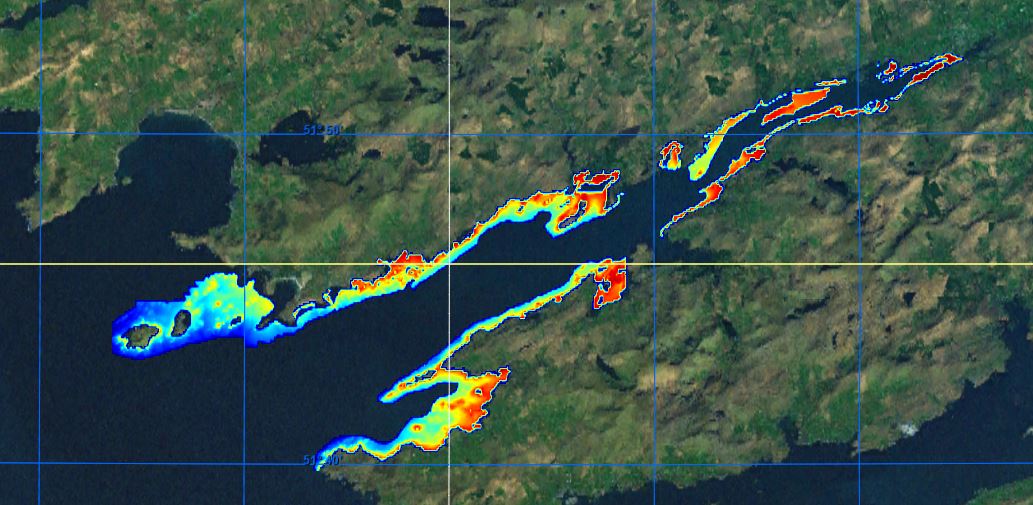
This composite Digital Terrain Model (cDTM) is a high resolution bathymetry dataset highlighting measurement of depth of water in the ocean. This cDTM covers the Kenmare Estuary off the coast of Co. Kerry in Ireland. The EMODnet high resolution DTM covers bathymetry surveys completed between during 2022. Bathymetric data collected on board research vessels using multi-beam and single-beam echosounder instrumentation. Raw bathymetry processed within CARIS software to produce bathymetry products subsequently converted to NetCDF cDTM for EMODnet. Acquisition, processing and product delivery follows IHO standard s44 Edition 5. cDTM is composed of four (4) images “merged simply” using GLOBE software. INFOMAR (Integrated Mapping for the Sustainable Development of Ireland's Marine Resource) is a twenty year program to map the physical, chemical and biological features of Ireland's seabed established in 2006. INFOMAR is funded by the Department of Communications, Climate Action and Environment (DCCAE), and delivered by joint management partners Geological Survey Ireland and the Marine Institute. The program is the successor to the Irish National Seabed Survey (INSS) which ran between 1999 and 2005. INFOMAR concentrates on creating integrated mapping products related to the seabed.
-
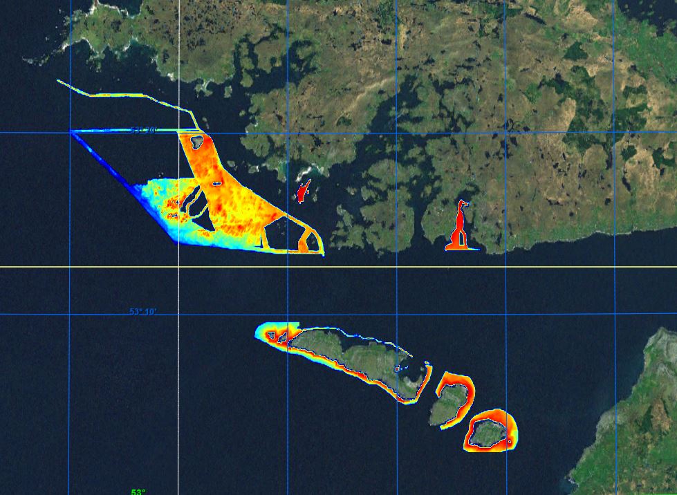
This composite Digital Terrain Model (cDTM) is a high resolution bathymetry dataset highlighting measurement of depth of water in the ocean. This cDTM covers Galway Bay and Aran Islands off the coast of Co. Galway in Ireland. The EMODnet high resolution DTM covers bathymetry surveys completed between during 2022. Bathymetric data collected on board research vessels using multi-beam and single-beam echosounder instrumentation. Raw bathymetry processed within CARIS software to produce bathymetry products subsequently converted to NetCDF cDTM for EMODnet. Acquisition, processing and product delivery follows IHO standard s44 Edition 5. cDTM is composed of two (2) images “merged simply” using GLOBE software. INFOMAR (Integrated Mapping for the Sustainable Development of Ireland's Marine Resource) is a twenty year program to map the physical, chemical and biological features of Ireland's seabed established in 2006. INFOMAR is funded by the Department of Communications, Climate Action and Environment (DCCAE), and delivered by joint management partners Geological Survey Ireland and the Marine Institute. The program is the successor to the Irish National Seabed Survey (INSS) which ran between 1999 and 2005. INFOMAR concentrates on creating integrated mapping products related to the seabed.
-
This composite Digital Terrain Model (cDTM) is a high resolution bathymetry dataset highlighting measurement of depth of water in the ocean. This cDTM covers the Celtic Sea Basin off the coast of Co. Cork in Ireland. The EMODnet high resolution DTM covers bathymetry surveys completed between during 2022. Bathymetric data collected on board research vessels using multi-beam and single-beam echosounder instrumentation. Raw bathymetry processed within CARIS software to produce bathymetry products subsequently converted to NetCDF cDTM for EMODnet. Acquisition, processing and product delivery follows IHO standard s44 Edition 5. cDTM is composed of three (3) images “merged simply” using GLOBE software. INFOMAR (Integrated Mapping for the Sustainable Development of Ireland's Marine Resource) is a twenty year program to map the physical, chemical and biological features of Ireland's seabed established in 2006. INFOMAR is funded by the Department of Communications, Climate Action and Environment (DCCAE), and delivered by joint management partners Geological Survey Ireland and the Marine Institute. The program is the successor to the Irish National Seabed Survey (INSS) which ran between 1999 and 2005. INFOMAR concentrates on creating integrated mapping products related to the seabed.
-

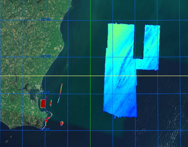
The "EMODnet Digital Bathymetry (DTM)- 2022" is a multilayer bathymetric product for Europe’s sea basins covering: • the Greater North Sea, including the Kattegat and stretches of water such as Fair Isle, Cromarty, Forth, Forties,Dover, Wight, and Portland • the English Channel and Celtic Seas • Western Mediterranean, the Ionian Sea and the Central Mediterranean Sea • Iberian Coast and Bay of Biscay (Atlantic Ocean) • Adriatic Sea (Mediterranean) • Aegean - Levantine Sea (Mediterranean). • Madeira and Azores (Macaronesia) • Baltic Sea • Black Sea • Norwegian and Icelandic Seas • Canary Islands (Macaronesia) • Arctic region and Barentz Sea The DTM is based upon 21937 bathymetric survey data sets and Composite DTMs that have been gathered from 64 data providers from 28 countries riparian to European seas and beyond. Also Satellite Derived Bathymetry data products have been included fro Landsat 8 and Sentinel satellite images. Areas not covered by observations are completed by integrating GEBCO 2022 and IBCAO V4. The source reference layer in the portal viewing service gives metadata of the data sets used with their data providers; the metadata also acknowledges the data originators. The incorporated survey data sets itself can be discovered and requested for access through the Common Data Index (CDI) data discovery and access service that in December 2022 contained > 41.000survey data sets from European data providers for global waters. The Composite DTMs can be discovered through the Sextant Catalogue service. Both discovery services make use of SeaDataNet standards and services and have been integrated in the EMODnet portal (https://emodnet.ec.europa.eu/en/bathymetry#bathymetry-services ). In addition, the EMODnet Map Viewer (https://emodnet.ec.europa.eu/geoviewer/ ) gives users wide functionality for viewing and downloading the EMODnet digital bathymetry such as: • water depth (refering to the Lowest Astronomical Tide Datum - LAT) in gridded form on a DTM grid of 1/16 * 1/16 arc minute of longitude and latitude (ca 115 * 115 meters). • option to view depth parameters of individual DTM cells and references to source data • option to download DTM in 58 tiles in different formats: ESRI ASCII, XYZ, EMODnet CSV, NetCDF (CF), GeoTiff and SD • option to visualize the DTM in 3D in the browser without plug-in • layer with a number of high resolution DTMs for coastal regions • layer with wrecks from the UKHO Wrecks database. The EMODnet DTM is also available by means of OGC web services (WMS, WFS, WCS, WMTS), which are specified at the EMODnet Bathymetry portal. The original datasets themselves are not distributed but described in the metadata services, giving clear information about the background survey data used for the DTM, their access restrictions, originators and distributors and facilitating requests by users to originator.
-
The "EMODnet Digital Bathymetry (DTM)- 2022" is a multilayer bathymetric product for Europe’s sea basins covering: • the Greater North Sea, including the Kattegat and stretches of water such as Fair Isle, Cromarty, Forth, Forties,Dover, Wight, and Portland • the English Channel and Celtic Seas • Western Mediterranean, the Ionian Sea and the Central Mediterranean Sea • Iberian Coast and Bay of Biscay (Atlantic Ocean) • Adriatic Sea (Mediterranean) • Aegean - Levantine Sea (Mediterranean). • Madeira and Azores (Macaronesia) • Baltic Sea • Black Sea • Norwegian and Icelandic Seas • Canary Islands (Macaronesia) • Arctic region and Barentz Sea The DTM is based upon 21937 bathymetric survey data sets and Composite DTMs that have been gathered from 64 data providers from 28 countries riparian to European seas and beyond. Also Satellite Derived Bathymetry data products have been included fro Landsat 8 and Sentinel satellite images. Areas not covered by observations are completed by integrating GEBCO 2022 and IBCAO V4. The source reference layer in the portal viewing service gives metadata of the data sets used with their data providers; the metadata also acknowledges the data originators. The incorporated survey data sets itself can be discovered and requested for access through the Common Data Index (CDI) data discovery and access service that in December 2022 contained > 41.000survey data sets from European data providers for global waters. The Composite DTMs can be discovered through the Sextant Catalogue service. Both discovery services make use of SeaDataNet standards and services and have been integrated in the EMODnet portal (https://emodnet.ec.europa.eu/en/bathymetry#bathymetry-services ). In addition, the EMODnet Map Viewer (https://emodnet.ec.europa.eu/geoviewer/ ) gives users wide functionality for viewing and downloading the EMODnet digital bathymetry such as: • water depth (refering to the Lowest Astronomical Tide Datum - LAT) in gridded form on a DTM grid of 1/16 * 1/16 arc minute of longitude and latitude (ca 115 * 115 meters). • option to view depth parameters of individual DTM cells and references to source data • option to download DTM in 58 tiles in different formats: ESRI ASCII, XYZ, EMODnet CSV, NetCDF (CF), GeoTiff and SD • option to visualize the DTM in 3D in the browser without plug-in • layer with a number of high resolution DTMs for coastal regions • layer with wrecks from the UKHO Wrecks database. The EMODnet DTM is also available by means of OGC web services (WMS, WFS, WCS, WMTS), which are specified at the EMODnet Bathymetry portal. The original datasets themselves are not distributed but described in the metadata services, giving clear information about the background survey data used for the DTM, their access restrictions, originators and distributors and facilitating requests by users to originator.